¶ Map Layer Panel
The layers panel shows a list of all map layers that are available. It allows you to toggle layer visibility and change layer specific settings.
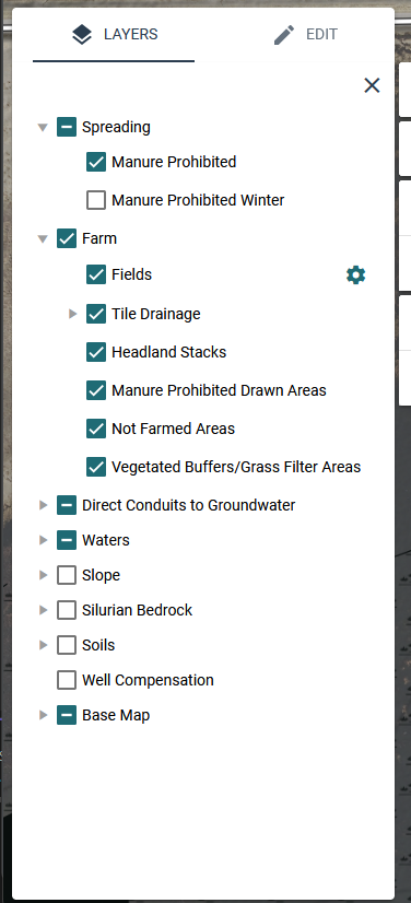
On small screens, it may be helpful to hide the layers panel when you’re not using it. You can close it by clicking the X in the upper right corner. You can reopen it by clicking the Layers tab again.
¶ Structure
The layers panel is divided into groups and individual layers.
Layer Groups
- Each group contains layers that share a common theme
- Groups can be identified by looking for an arrow to the left of the heading
- You can expand a group to view its layers by clicking the arrow to the left of the group name
- You can toggle the visibility of all layers in a group by clicking the checkbox next to the group name
Layers
- Layers contain the features that are being shown on the map
- Each layer can be toggled on or off independently by clicking the checkbox next to the name of the layer
¶ Layer Settings
Some layers have additional settings that can be adjusted. These layers will have a gear icon to the right of their name. To access the settings,
- Open Settings: Click the gear icon to the right of the layer name.
- Adjust Settings: Modify the settings as needed.
- Hide Settings: Click the gear icon again to hide the options once you're done.
¶ Layer Data Sources
We collect data from various federal and state entities.
Some key sources are:
- Soil Survey from United States Department of Agriculture Natural Resources Conservation Service (USDA NRCS)
- State data from Department of Natural Resources (DNR) Open Data Portal
- Silurian data from Wisconsin Geological and Natural History Survey
- Local data from county conservation departments
- See the Aerial Imagery page for additional details about map imagery sources.
¶ Downloading Map Data
A geodatabase of map layers is available for download from the Wisconsin Department of Agriculture, Trade, and Consumer Protection (DATCP) open data site
For detailed layer descriptions, download snapmaps_nm_layer_descriptions.xlsx
¶ FAQ
How do I know what each layer looks like?
To identify what each layer looks like, you can use the legend tool. The legend tool ![]() shows a list of each layer’s map symbol.
shows a list of each layer’s map symbol.
Why can’t I see a layer I’ve turned on?
There are a couple reasons you may not being seeing a layer that you’ve enabled.
- Zoom Level: You might not be zoomed in far enough to see the layer. To improve map performance, many layers are only visible at closer zoom levels. Try zooming in to see if the layer becomes visible.
- No Features in View: The layer might not have any features within the current map area you're viewing. Try panning to a different area to see if the layer appears.